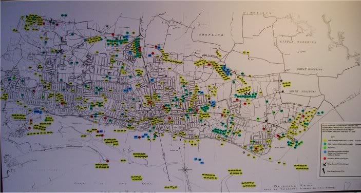
This map shows the locations of all the known locations that bombs fell on Southend, I have also listed the known statstistics of what fell.
Air Raids
Warings: 1236
Raids: 85
H-E: 567
I-B: 12454
LM: 13
Butterfly: 185
Phosp: 22
Oil: 5
V1: 5
V2: 2
Casultys
Killed: 62
Inj: 370
Damage to Buildings
Dest: 350
Major Dam: 900
Light-Mod Dam: 14000

By: WJ244 - 6th September 2021 at 09:32
I believe the person who started this thread was Nick Skinner who sadly passed away a few months ago.
By: sadshe - 4th September 2021 at 18:50
Dear Old Fart,
Do you still have copies of the bomb map that you can share? I’d love to see a detailed copy if you have.
Regards, Sadshe
By: Old Fart - 22nd January 2006 at 23:39
all 3500+tons of it!
By: Rich82 - 22nd January 2006 at 18:31
Very interesting map, makes for intriguing perusing.
What was the total tonnage of bombs dropped? Do you know?
Seems to be a fair amount of damage, understandably. Damage which could be added to at some point, should the ammunition on the S.S Richard Montgomery go up!
By: Alan T - 22nd January 2006 at 14:05
Charley, you may be interested in the attached (poor quality) shot of Dornier DO 17z-3 U5 + LK of 2/KG2 that was taken at RAF Rochford (Southend) on 26th August 1940, after a forced landing – crew were captured uninjured. You can make out St Andrews (Rochford) Church tower and the Rochford Hospital chinmney on the skyline, over the right wing. I believe the picture was originally published in the Southend Standard.
Note – haven’t tried attaching pictures before, hope it works OK!
By: Old Fart - 18th January 2006 at 13:44
Its got a few bombs marked up,
I’ll take a photo of the airport aera
By: Charley - 18th January 2006 at 12:21
Does the map include attacks on the former RAF Rochford?
By: Old Fart - 18th January 2006 at 10:56
I have the original at 1.8mb I will go and get a few more of the map this week or next, I will also try and do sections of it to make a larger picture up.
Nick
By: Gooney Bird - 18th January 2006 at 10:02
I spent most of my childhood in Southend so would also appreciate a copy too.
By: --o-o-O-o-o-- - 18th January 2006 at 08:54
If anyone does manage to get a higher resolution image, I’d appreciate a copy too….
By: scotavia - 17th January 2006 at 23:34
V weapons plots
Sort of a QI comment…..in order to mislead the German forces who were responsible for launching the V weapons a very detailed plan of disinformation was put in place. This involved moving the reported location of where the missiles and rockets crashed. Normally censorship allowed photos of raid damage to be published with very general locations,this rule was altered to allow enough false info to be used. All axis spies landed in the UK were turned into double agents and they were also used to send false reports.
The ruse did work..actual plots of the V weapons not destroyed in the air did show that gradually a shift to the West less populated areas of the South East of England occured.
For more info seek out the excellent back issues of After the Battle mag.
By: Old Fart - 17th January 2006 at 23:08
Jamie:
I do have a bigger picture of it if you want me to e-mail to you its not the best as I got knocked as I took it keep meaning to go and take another.
Alan:
Its on display in Southend untill next month.
By: Alan T - 17th January 2006 at 21:43
Old fart, is this map currently on display somewhere locally? Similar map covering Rochford district, along with other memorabilia, was on display in Hockley library last year – marked all V1, V2 ‘landing’ sites locally plus location of all British & enemy aircraft crash sites.
By: Jamie-Southend - 17th January 2006 at 21:23
Hi,
Do you have the picture in a higher resolution so we can see a bit more detail?


 Sign In
 January 17, 2006 at 3:50 pm