While the search for Steve Fossett was going on, I spend a lot of time searching for his aircraft on Google Earth (the Mechanical turk setup by Branson).
I participated in a Google forum, where we shared tips and tricks about such an image search. At least one of the forum users was a prof imagery analyst from the US armed forces, so we all got quite a few pointers regarding image interpretation.
This searching made me think about aircraft still hiding on various Pacific islands. I’m pretty sure all agree, that there are still plenty of wrecks around out there, but unfortunatly the boneyards have gone. However i belive it could be possible to locate relics/wrecks out there, by a coordinated scanning on Google Earth.
I have a list of all (or at least most) air fields in the Pacific area and have been scanning a bit, although mostly to determine the image quality.
I writing this to see if anyone would be interested in joining the attempt.
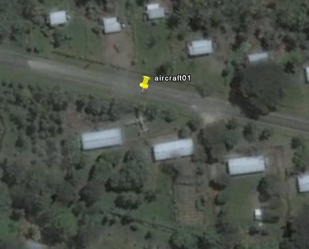
Here is what i found near an abandoned US base. The aircraft might be known to wreck-hunters, but it can serve to show how Google earth can be used this way.

By: airmanual - 25th February 2009 at 14:47
Hello,
An example of how it is unfortunately impossible to spot anything useful from Google earth.
Please go to PAGAN ISLAND
It’s an island in the Marianas with an ex Japanese aifield. Definition is good and the airfield (with a lot of bomb craters) is clearly visible. There are at least 2 fairly complete wrecks along the runway : a Zero and a Nell + a dump with a lot of partial wrecks along the shore. But unfortunately nothing is visible from Google Earth.
Laurent
By: Milton Andrade - 16th May 2008 at 03:02
Mondariz and Scorpion89, if the photo about the Invader was taken in the mid-90s then it should have been surrounded by Fouga Magisters and Ouragans, else (if surrounded by warbirds) it was taken in the mid-70s.
Is it possible to post the picture here?
Saludos.
By: Mondariz - 17th March 2008 at 08:23
There are still many wrecks throughout the pacific region.
Quite a large percentage is covered in jungle, and using GE in those areas would not yeild anything, even a B-29 would be able to dissapear completely.
However, there are areas, where the terrain/vegetation would leave an aircraft exposed. These are also the kind of areas, where a pilot might try to land a damaged/non-functioning aircraft.
The best example is “Swamp Ghost”. Clearly visible as a B-17 on Google Earth. Granted that particular aircraft was already discovered and thus easy to find. PNG is a huge island and its not impossible, that there are another “Swamp Ghost” out there.
In areas where the terrain is more barren (Norway, Sibiria, Canada ect.) I have located quite a few wrecks. Not as a “first find” but simply to see what could be found.
Apart from the minute chance of finding a new wreck, my main reason to searech those areas is simple curiosity. Anybody who have read about the pacific war, would know those exotic names: Gilbert islands, Tinnian, Iwo Jima ect.
Seeing the remains of WWII bases and fortifications today brings history up close. Tiny Tinian island is still clearly marked by the airbase, where 500 bombers operated. Just thinking about that number on such a small island is fantastic.
There are also shipwrecks visible around many islands.
D-Day wrote:
“I can see one or two parts dealers Errrr…. sorry, I mean Historians, I can think of two right now, taking a much closer look at their G E.
Is this kind of publicity really for the best one wonders ?”
I think finding the aircraft is rather “easy”, compared to the task of getting recovery permission. AFAIK there are already quite a few aircraft, where people are already trying to get recovery permissions.
Besides, GE searching is mostly for people, who can’t actually go there and search local archives, talk to local people and otherwise take the most direct route. Apart from using GE for terrain evaluation, search planning and general area familiarisation, I don’t think actual wreckhunters use it much. Its too much work 🙂
By: JonL - 17th March 2008 at 05:25
Would be great if GE could penetrate the bush in Papua New Guinea to find some of the many aircraft still missing…a lot of families still waiting for closure.
A mate of my brother was logging in PNG in the late 60’s, early 70’s. He said they came across wreckage about once a month, once with the remains of the pilot nearby.
Their usual course of action was to bulldoze it out of the way!!!!!!
They were after logs, not the hassles of old aircraft recovery…….
By: Arabella-Cox - 16th March 2008 at 23:45
I can see one or two parts dealers Errrr…. sorry, I mean Historians, I can think of two right now, taking a much closer look at their G E.
Is this kind of publicity really for the best one wonders ?
By: Arabella-Cox - 16th March 2008 at 15:45
Quote:
Originally Posted by JDK“Satellite imagery was Jim Pearce’s ‘secret weapon’ in finding airframes in the former Soviet Union long before Google Earth became available to the masses. Presumably he paid someone, NASA or the Russians, for access. “
This is very likely to be incorrect. The majority of ‘Diggers’ in Russia locate old wreck sites ‘using’– often which means by stealing– historical material from various archival collections. Their main targets are documents produced by the NKVD relating to wreckage sites during the War, which not only pin-point the locations of the examples, but also their exact condition at the time they were investigated. Photographs of the site, maps and location hints are usually also provided.
Many examples of such superb documentation may be found relating to the area where this chap’s contacts seem to operate (i.e. in the greater area around and north of St. Petersburg). This is so as the wartime Baltic Fleet (KBF) received many copies of these wreckage reports from the PV NKVD, and retained these in the quite impressive collection of the Central Military Naval Archives at Gatchina (TsVMA). With such excellent material, the diggers are rather successful to locate many such historical items and wrecks.
I have searched for aviation artefacts in this area myself, and I can assure you that aerial photography would be of very limited use, if any at all. Many of the wrecks are found preserved in the mud at the bottom of shallow pools, marshland, and under considerable vegetation, and could never be seen from above.
By: Mondariz - 16th March 2008 at 06:56
Mondariz,
I came across this pic on a link in another KP thread, but it graphically shows what jungle can do to hide an airframe, making location by air or GE very difficult.
Even though it appears to be in a clearing, its broken form, discolouration and partial covering of leaves and plants would make it virtually impossible to locate from the air.
Regards
Mark Pilkington
Hi Mark,
Thanks for posting the picture.
Yes, it would be hard to locate a wreck like that (lets say impossible). The same goes for 99.99% of pacific wrecks, maybe even more :p
My idea was to scan for obvious wrecks (like “Swamp Ghost”). There might not be any wrecks like that left, but just maybe there is one out there.
We have all heard about the “lost dump-site on PNG” legend. Not that i fully belive it, but it cost me nothing to spend an hour now and again looking for it.
That aside, I have now reconsidered my GE search and are currently searching airports/airfields for various “parked” aircraft. For obvious reasons i seem to find a lot more that way 😀
BTW you can use ICAO airport codes on Google earth. Key in the four letters and GE will take you straight there.
By: mark_pilkington - 15th March 2008 at 20:39
Mondariz,
I came across this pic on a link in another KP thread, but it graphically shows what jungle can do to hide an airframe, making location by air or GE very difficult.

Even though it appears to be in a clearing, its broken form, discolouration and partial covering of leaves and plants would make it virtually impossible to locate from the air.
Regards
Mark Pilkington
By: Mondariz - 5th March 2008 at 06:40
It seems that AirPirates are recovering a B-17 from somewhere. I remembered seeing the picture earlier this year, but didn’t really think GE.
http://www.airpirates.com/gallery/album03/B_17G
I have tried to find more information, but have not really been able to yet. And it seems that the WIX forum has been talking about it, without indentifying it. This could suggest that the B-17 is “new”, or should we say a forgotten aircraft resently located.
That aside, if aircraft was anywhere near the depicted condition when found, it would clearly have been possible to locate it using GE (providing that the resolution was fair).
I do realise that the area (sand or snow it seems) don’t compare to the Pacific, but it could nevertheless points to GE’s use as a search tool.
If the aircraft is a resent find, it shows that there could easily be whole aircraft waiting out there.
A problem in using GE for searching, is the difficulty in identifying fighter size aircraft. Browsing various central american boneyards, its normally easy to indentify the AC type for DC-3 size aircraft, but anything smaller all look like Harvards (to me anyway) unless is has some distinct feature, like a twin tail.
By: Mondariz - 2nd March 2008 at 07:43
“Most of the photos on the net are at least 2-15 Years Old.”
Not sure where you get that age from?
Are you talking about GE images, or pictures in general?
I did not intend to imply that I saw them on GE. What i did intend to show, was that by finding photos from around the world, you can get a good few places to search.
Other people than the warbird recovery chaps like to take pictures of old aircraft. Many post their holiday pics on places like flickr, and with time and patience, you can find a few birds in the collection.
I’m not saying its an easy way to locate anything, but with the millions of pictures available, a bit of travling (searching) can produce something. After that its a question of asking around, to see how well known the relic/wreck is.
Here is one i found yesterday:
I’m still waiting to hear about the location.
By: Scorpion89 - 2nd March 2008 at 07:31
I seem to read my post as “Hard to say how old the picture is, but it didn’t look too old, maybe sometime in the 90’s.
Yes I read your post and that is why I said that the phoots where 15 Years Old
I never said i saw them on GE.
Maybe not in word but implied that you found it with GE
Looking at airfield boneyards around the world, is pretty good practice for anyone who would like to search for aircraft this way. You get a lot better at identifying aircraft from the air, because you often have actual photos of the area (if you have the time to find them, on aircraft websites, or even on Flickr).
Thanks I didn’t know that jeeze why didn’t I and the rest of us who hunt wrecks think of that. Most of the photos on the net are at least 2-15 Years Old.
Nice to know some of the El Salvadorians made it. Do you know what happened to the A-26?
It was recovered by David Tallichet in the mid 80s.
By: Scorpion89 - 2nd March 2008 at 07:27
If as Mark said, the B-24 was seen on aerial photos, why don’t you think it can be seen on Google Earth (providing the resolution for the area is fair to doog)?
Its pretty much the same thing.
The photo was taken in the early 70s from a Recon aircraft looking for something else. It was a very poor BW photo, When the guy removed the P-61 they try to located the B-24 and they couldn’t find it from the air even thou they had the basic location. The location is high up and doesn’t get logged and very few Fire happen to keep the growth down.
By: Mondariz - 2nd March 2008 at 06:55
Except that those images are 15 years old, as someone else has pointed out most of the South of the Border stuff on GE is rather old. The A-26 is no long there, the three T-6 have long been moved one is even flying now in the States and the P-51 fusl. is under restoration now. The two C-47 are still their along with the burnt out CASA.
I seem to read my post as “Hard to say how old the picture is, but it didn’t look too old, maybe sometime in the 90’s.“
I never said i saw them on GE.
Looking at airfield boneyards around the world, is pretty good practice for anyone who would like to search for aircraft this way. You get a lot better at identifying aircraft from the air, because you often have actual photos of the area (if you have the time to find them, on aircraft websites, or even on Flickr).
Nice to know some of the El Salvadorians made it. Do you know what happened to the A-26?
By: Mondariz - 2nd March 2008 at 06:49
If as Mark said, the B-24 was seen on aerial photos, why don’t you think it can be seen on Google Earth (providing the resolution for the area is fair to doog)?
Its pretty much the same thing.
By: Scorpion89 - 2nd March 2008 at 06:47
I resently saw a picture from El salvador with an unmarked A-26 sitting pretty between a few other planes (most if “fair” condition, not hulks or wrecks, but maybe lacking a prop, or canopy). One of the planes looked pretty much like a P-51, another was a Texan. Hard to say how old the picture is, but it didn’t look too old, maybe sometime in the 90’s.
Except that those images are 15 years old, as someone else has pointed out most of the South of the Border stuff on GE is rather old. The A-26 is no long there, the three T-6 have long been moved one is even flying now in the States and the P-51 fusl. is under restoration now. The two C-47 are still their along with the burnt out CASA.
By: Scorpion89 - 2nd March 2008 at 06:43
Mark,
Oh man the B-24 crash photo I went back thru some of my old hard drive stuff to see if I had any of the photos(still looking) the plane was from the 380th BG Flying Circus and was lost along the Puncak Jaya located in the Central Mountain Range.
I recall that Indiana Tony,Jungle Bob and myself have quite a discussion about this wreck on the old Warbird Worldwide Group(remember that one:( ).
I don’t think GE is going to find that one at all. Now as for the whole P-3 discussion yes it is relevant to the topic if you all go back and read what I aid we use a P-3 to help search some possible White Bird locations.
By: Mondariz - 2nd March 2008 at 06:00
I remember that pic – it used to be up on barnstormers – in the very early days!
I knew someone who told me he had some pics of it but never saw them.
It’s probably still there – one for Mondariz to find I think 🙂
.
Hmmmmm seems like an even bigger task 😮
As I said earlier, I will work through the information I can find (regarding the pacific) and pick a few choice locations for scanning.
In the mean time I will browse remote airfields (not only pacific) and see what I can find. I resently saw a picture from El salvador with an unmarked A-26 sitting pretty between a few other planes (most if “fair” condition, not hulks or wrecks, but maybe lacking a prop, or canopy). One of the planes looked pretty much like a P-51, another was a Texan. Hard to say how old the picture is, but it didn’t look too old, maybe sometime in the 90’s.
By: Mondariz - 2nd March 2008 at 05:52
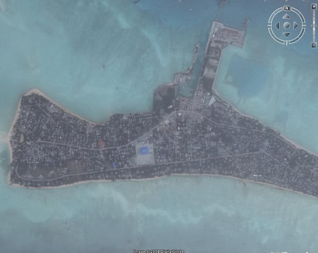
Looks like there’s something in the water in the bottom left of that pic.
Maybe a landing craft or something?
There are plenty ship wrecks in that area. Inside the atoll you can also see a few.
By: Mondariz - 2nd March 2008 at 05:50
Hi Mondariz
Thanks for posting that image of Betio, it doesn’t look like anyone will find any ‘wrecks’ lurking under a bush there! The image does astound me though as every WW2 era photo I have seen shows about 5 buildings for the whole island, lots of smashed palm trees and bomb craters – I had naively assumed that it would still look like an idyllic tropical island – not a metropolis.
Paul
PS If nobody has any passion or willingness to try out new ideas then they wouldn’t get anywhere.
Betio has changed alot, but most of the other atolls are still pretty deserted.
If you want other images from the area just tell me.
Or I can send you some information about Google Earth. If you have “broadband” (here meaning not phone-up connection) its very easy to install and its free.
By: Anark - 1st March 2008 at 23:23
Here is the GE image from Betio island. As you can see its pretty build up.
There are a number of islands/atolls in the area, each with their own airfield. The airfield i have listed as Tawara airfield, is on an island to the north. Obviously they can’t all be Tarawa airfield.
Looks like there’s something in the water in the bottom left of that pic.
Maybe a landing craft or something?


 Sign In
 February 28, 2008 at 8:48 pm