Looks like there’s something in the water in the bottom left of that pic.
Maybe a landing craft or something?
There are plenty ship wrecks in that area. Inside the atoll you can also see a few.
Hi Mondariz
Thanks for posting that image of Betio, it doesn’t look like anyone will find any ‘wrecks’ lurking under a bush there! The image does astound me though as every WW2 era photo I have seen shows about 5 buildings for the whole island, lots of smashed palm trees and bomb craters – I had naively assumed that it would still look like an idyllic tropical island – not a metropolis.
Paul
PS If nobody has any passion or willingness to try out new ideas then they wouldn’t get anywhere.
Betio has changed alot, but most of the other atolls are still pretty deserted.
If you want other images from the area just tell me.
Or I can send you some information about Google Earth. If you have “broadband” (here meaning not phone-up connection) its very easy to install and its free.
Close to what i posted just a minute ago, but since its the “Victorious Fatherland War Museum” and not a aircraft/aerospace museum, I’m pretty sure they have used wrecks on purpose.
No point of showing the enemy to have been strong (or posessing better technology).
This might not mean, that they have better aircraft somewhere else, just that I don’t think the wrecks on display mean anything.
Hi Joe,
Thanks for clearing up the F-51 location. I simply grapped the picture somewhere and placed it here as described.
I have seen a few pictures from “Victorious Fatherland War Museum” and just assumed the state of the “Yankee” planes was deliberate, to show the people what little there was left of the enemy. In other words – propaganda.
From your post it seems that the “best” possibility is of finding a wreck, and not whole abandoned aircraft.
Seems too much trouble to battle the North Korean state beaurocracy, just to get the chance of finding a wreck, which could be found in other parts of the world.
Of cause there is a question of MIA airmen, but I’m sure the US is working on that.
Hi Mark,
You are absolutly right.
The merit of the Fossett search is of no matter regarding wreck searching.
I for my part, will refrain from pissing in the future 😉
And regarding the armchair searching, you are right again.
I have already found a number of interesting aircraft. Not in the pacific, but around airports/fields in the less traveled parts of the world. Quite a few have their own little boneyard and for anyone wanting to search on Google Earth, thats a perfect place to start.
This forum can always be used for identification and to see if the bird is “known”.
Someone in another forum I read, said something quite true about warbird restoration – The main source is not pacific jungles, but the junkyards.
I have read about sat pics of a Corsair, but thats really all i could find.
I seem put to the wall by unconfirmed and secret knowledge about US military involvement in the Steve Fossett search :rolleyes:
Despite personally knowing the person who found one of the aircraft (although not through GE), but i guess that AC was found by the P-3 too.
It seems my list pointed to the Abaiang atoll, rather than Tarawa.
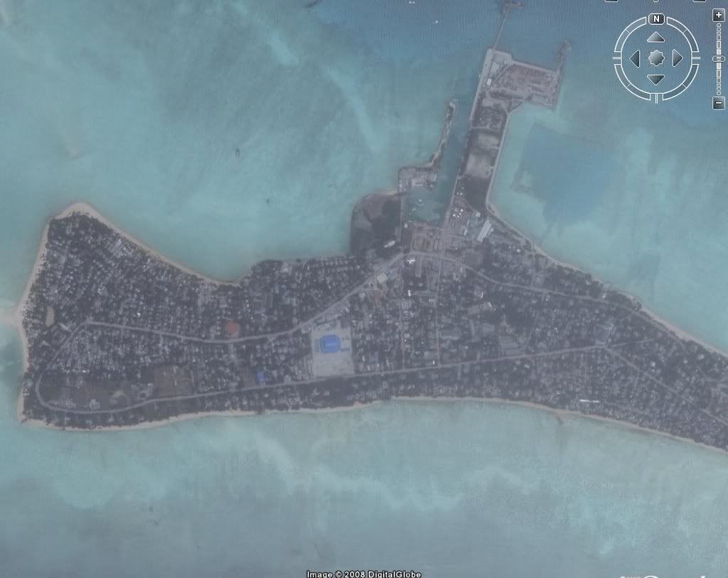
Here is a map of Betio Island, it is the southernmost island in the atoll of Tarawa and the scene of the main Japanese base and subsequent amphibious assault by the Marines. The map is A3 and would not fit properly on my scanner – taken from “US Army in World War 2” it has the most outstanding battle maps I have seen. It would appear to be fairly easy to compare the original maps and aerial photographs to current GE images
Paul
Here is the GE image from Betio island. As you can see its pretty build up.
There are a number of islands/atolls in the area, each with their own airfield. The airfield i have listed as Tawara airfield, is on an island to the north. Obviously they can’t all be Tarawa airfield.
BTW i love the idea, that you seem to think that a sweep by a P-3 (in the general area) would produce more results than CAP could in weeks.
We had a guy in the forum (Fossett search forum) who seemed to think a U2 would find Fossett in a matter of minutes.
Military technology is pretty good, but its no miracle.
I have an article where the CAP search leader state that those 5 aircraft were found by GE searchers.
The actual sequence of events:
The boxes containing the aircraft were flagged in google earth (by a large % of users).
The Hilton team (Baron Hilton was leading the private search team) evaluated those boxes and forwarded the position to CAP.
CAP flew a search on the location.
There were no P-3 involved, I don’t know where you have this infomation, but its simply not true. We had very close contact with the Hilton search team and with CAP. What they did use, was the CAP ARCHER system. However, that did not find those planes (unless it was after the location was reported through GE).
We are very much aware, that certain parts of CAP had their own spin on the events, as they did not like this kind of “competition”. But there are also people in CAP, who see the possibility of GE searching.
The main problem in that search, was the lack of training. They had people report trucks, aircraft in flight, and other objects which proved false positives.
I never said the Fw 189 was found on Google Earth, just that it would have been seen by GE searchers. I have also said, that any pacific search would be organised after Squadron records and loss reports. Neither did i say, that it would revolutionize wreck-hunting. I just said that it could be a tool for people how would like to search, but can’t/won’t go to the location. I also said (and proved to some extend) that it would be possible to find a WWII aircraft by usuing Google Earth.
There is no reason to keep mentioning, that “its a jungle out there”. I’m pretty well aware of the jungle, and how you can’t see an aircraft (or anything else)) underneath 60 years of jungle growth. Its just not all jungle. Naturally a GE search would be in areas, where it would be possible to see something. I’m not going to search the Pacific ocean either (and im rather surpriced nobody have pointed that out yet).
Your last paragraph hits the nail – Its fun to search on GE!
my earlier post was not meant to dismiss your idea, anything but, i would be only to pleased to help out, i was just pointing out, with my limited experiance, the idea seems immense, but if you have plans of how to ease this, and make it into a organised project, then good on you. I look forward to seeing your plans in action and getting involved.
Happy to hear some enthusiastic feedback and I will keep you in mind, when i get some search boxes ready.
You are right (and most other posters too), it is an immense undertaking and thats why I hoped to get a few helpers.
I think I will focus on dividing the task into parts that people can understand. Not suggesting that people here can’t understand a complex task, but I have found that the scale of the job are beyond the grasp of alot of readers.
Personally I have no problem with the scale of the task, but I also understand how readers might find it slightly insane :confused:
Maybe they are right, it does sound pretty odd.
My next step will be sorting a specific area for scanning, then i will ask again. Hopefully we can find some help then.
It has been great to get feedback from the warbird community and i do appreciate every single post, as I know many of you have more knowledge of warbirds and recovery than I might ever get.
I just think I know a bit more about the Google earth technology, than the avarage wreck-hunter. Not trying to put anyone down (or raise my own light), maybe I just see a potential (however small) and want to have a bit of fun with it.
Again, I never said this project would find warbirds, just that it would let many people participate in the search.
Well, yes, of sorts…bearing in mind that the image quality he bought would probably have been superior to Google Earth.
Unless he had VERY good connections, it would be worse.
Goole earth provides the best resolution outside state organisations. They provide the image resolution CIA and other agencies had in the 70’s and 80’s.
The stories about reading headlines from space are just stories.
Unless he had access to a keyhole sat (and they don’t use let people juse keyholes) he would have had lower resolution that standard Google earth.
To be short; he could not have had access to a keyhole and thus not have had better images.
Satellite imagery was Jim Pearce’s ‘secret weapon’ in finding airframes in the former Soviet Union long before Google Earth became available to the masses. Presumably he paid someone, NASA or the Russians, for access.
Vindication!
Of sorts 😀
Mondariz,
I think we all agree that if you restrict your search to areas where known losses are listed you may well find something new, but finding that wreck in the Russian wilderness via GE scanning would still be like finding a needle in a haystack IMHO.
Regards
Mark Pilkington
Absolute truth, the needle and haystack analogy.
I never said I would be searching randomly throughout the pacific. There are areas more interesting than others. “Unfortunatly” most known areas have been searched by ground teams, although this doesn’t mean nothing new can be found there.
What this really amounts to, is an armchair project for people who like to think, that an unknown plane can be found on the pacific islands – no more, no less.
Its a past-time like plane-spotting (although you have to be a pretty lousy plane-spotter not to spot anything).


 Sign In