i have used GE in the past, to look ‘over walls’, to see things in places i have always know have hidden stuff- the fire dump at Manston and Gun towers in the thames estuary. If fact went out for a few weeks with a back problem last year i spent a couple of weeks looking at pretty much every airbase in the UK. But ever knowing the geographical positions of these places it still took quite some searching, so to look for a tiny object in such massive amounts of space must be overwhelming. So unless you know a position it would be more or less useless!
Google earth found 5 missing planes during the Steve Fossett search…..Not relativly solid WWII fighters/bombers but flimsy GA aircraft, which crumple up into nothing (unfortunatly).
Its far from useless, although those planes needed confirmation from a ground team (but thats pretty much what im suggesting here too).
Do you think this aircraft would have been seen on Google Earth, before it was found by ground teams?
Fw 189 recovered by Jim Pearce 1990.
Better add that this is NOT the pacific and the vegatation is different, before people start pointing that out.
Not all areas of the pacific is jungle either.
Anyway, If such a wreck searching “technology” is made available, I’m pretty sure the gound searchers would avail of it, before trotting into the jungle/swamp.Maybe it could help them, maybe it couldn’t, but it will never make their starting position worse.
But it needs to be available and ready, before anyone would consider asking for an area scan.
BTW I do have access to the assistance of a professionel imagery analysts working for the US government. Although she would not be part of the project, she would be able to lend assistance now and again.
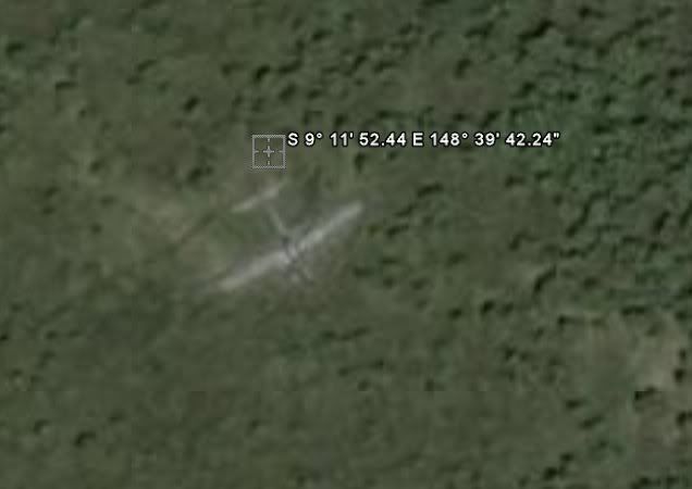
Just adding here, that Swamp Ghost was found less than 2 miles from a local village.
Perhaps then this is the real value that GE could be put to, rather than endlessly searching the wider pacific landscape, undertake a project to establish a website of GE images of Japanese and Allied airfields, with natural and “enhanced” images, and other support data as an online resource and historical record.
The “Enhanced” image could overlay the original layout of taxiways / revetments, runways, buildings, workshops, fuel dumps, repair yards. This would require a bit of work to use the GPS co-ords on the the GE images against accurate wartime scale maps, but the outcome would be of great use in a number of ways:
1. anomolies at the site could be interpreted relative to the historical land use, ie is it a building remains or possible aircraft part – your intended purpose.
2. Tourist or other visitors could orientate the current landscape against the historical landscape, adding to the interest etc of a visit, regardless of the purpose.
3. Forms an historical/ heritage study resource in its own right, ie understand where the historical boundaries of Clark Field in the Philippines, or Jacksons Field in Port Morseby PNG were, regadless of current redevelopment etc, even though there is no “warbird” recovery aspects to such information it is a valuable historical tool.
4. Provides an online historical and tourism resource for the Pacific Islands involved, who might then become a bit more actively involved in preserving some of the remaining relics? – perhaps even providing images of relics still remaining, (and helping to identify the anomolies found??)
The GE images, together with the mapped overlays could then be supported with historical photos of the base during the war and a short history of operations, creating an online resource for all of the above outcomes, and still creating the opportunity to trip over something of interest in the process?
Such a project may enlist far more helpers willing to take on research and publishing of individual “airfields” as their own projects, all on the one website.
I do agree with other comments that the existing “Wreckologists” have a fair idea what is out there, and know the hot spots to still look in, historically know where the dumps were, or where the scrappers didnt get to, I dont see GE being of much interest to them as they have access to local resources to undertake on the ground or in the air investigations.
But GE can be used to provide more information on the web on these battlegrounds, and to encourage further presevation of what is left.
Regards
Mark Pilkington
Google earth already have this facility, so just get cracking 😉
Ground searching and Google earth don’t differ too much regarding a possible endless search. I’m currently following a “live” ground earch and hope they will find something. I will post the link when i get home, if anyone wants to follow them.
Here is a link for anyone not familiar with Google earth searching:
JDK, i will start looking, but its (as everyone including me keep saying) a HUGE task, and one that is almost impossible for one person.
The loss database needs to be searched and mapped.
The Google overlays needs to be filtered.
Areas where ground search has been done, needs to be mapped to the google overlays.
A webpage or stand alone application needs to be developed for assigning boxes and keeping track on hits (i have been working on such an application in connection with the site linked above).
I’m aware that people have found planes in the pacific, but mostly in areas where locals could give them some information, or where there has been a specific report from the event.
There are also areas without locals to ask. Clearly those areas would be a priority.
i have used GE in the past, to look ‘over walls’, to see things in places i have always know have hidden stuff- the fire dump at Manston and Gun towers in the thames estuary. If fact went out for a few weeks with a back problem last year i spent a couple of weeks looking at pretty much every airbase in the UK. But ever knowing the geographical positions of these places it still took quite some searching, so to look for a tiny object in such massive amounts of space must be overwhelming. So unless you know a position it would be more or less useless!
Its called searching.
The search areas would be chosen by resolution. There are already databases with allied air losses and it would be a relativly simple matter to map them, even if all don’t have an area location. High density areas would be searched first, then down the list.
I could easily find a few missing planes (in the loss database) and start by using their last known position. These things are already known (for some anyway).
Thats how ground searching is done.
How long do you think it would have taken to find Swamp Ghost by ground search?
They would still be searching. In some of those swamps a mile is a days march.
You’ve copied the fuselage into at least four places, you devil – and none are obvious. 😀
Mondariz, I had been to a crash site in Scotland and, before returning, checked the location on Google Earth for fun. It was low res and of no use at all – even knowing where the wreck was and what it looked like. I couldn’t even find a path on the mountain.
And think the help/advice being given here is that there are severe limitations to a search such as this. All you have to do is weigh up those limitations (including the time involved) against the possible benefits.
Good luck
The whole idea was to see if anyone else wanted to take part.
There is no realistic way to do it alone.
There are some pretty good resolution overlays for the pacific area, and naturally the search would only be in those areas. Check the Swamp Ghost images.
There are no severe limitations to a Google earth search, there might be a very small chance of finding anything, but that goes for land search as well.
In many places a sat image search is less limited than a ground search and vice versa. Its two different things, each with their scope and limits.
Try to think back on the number of AC found from the air.
Anyway, I was not thinking about people spending hours on end looking at images, but just scanning a few whenever they have time. Slowly a database would be built.
When i get home I will post a few Google links to Pacific bases, then you can see the resolution. There is no doubt that a plane could be found.
As for time, some people have spend years searching the ground, with nothing more that a few scattered remains to show for it. These things don’t nessesarily bring instant success.
The airfield on the Google image is located on a smaller atoll north of Tarawa. I’m not really sure if its the one called Tarawa air field, or if it had another name.
My google earth locations list call it tarawa air field, but there is a bigger atoll south of it, with a bigger airfield (still in use).
I will look for the guns when i have a bit of time.
Ok, my final post on the JDK post 😉
CAP (Civil Air Patrol) who do most air searching in the states, didn’t think Google Earth would be any good either.
Finding 5 unknown wrecks in the area where CAP searched did little to change their mind. But Google earth users found them never-the-less.
Also when someone plan a search trip to the Pacific area, they should have access to the area in the database (if there are good images) and use it to to evaluate possible areas, as these have already been seen – more eyes are often better.
Hi Mark,
I’m aware of the difficulty in spotting an AC part from Google earth.
As i keep mentioning, this database could be an aid for people who search by ground. They can look at the images and decide if they are going to look closer on a location.
During the Fossett search we saw plenty caravans, mine shafts, aircraft in flight and other things that might look like AC parts, but we also learned some lessons about telling the difference.
A relic like “Swamp Ghost” would be the holy grail of a Google Earth search, but i would settle for a number of anomalies that needs to be checked out from ground level.
BTW on the PBY picture, you would ask yourself: what can it be?
Had i seen that, I would flag it as a possible. Things don’t just arrive in a desert.
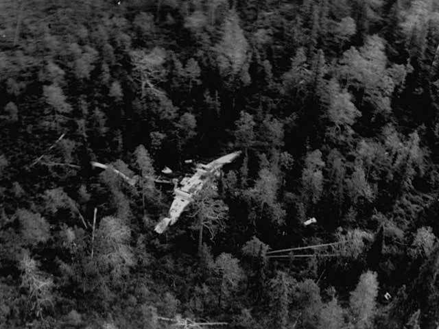
Here is “Swamp Ghost” seen from 7000′
Would you spot that on a fly-by?
Would you spot a fighter size aircraft?
This kind of relic might too much to hope for, but as it illustrates, its not impossible to dissapear in plane sight 😉

Here is “Swamp Ghost”, found by chance by RAAF in 1974 (New Guinea).
Here is a possible scenario, which might illustrate how i imagine the Google search.
A pilot is bringing home a damaged plane. On finding that he can’t make it, he aims for an clearing in the jungle.
This jungle clearing might not be visited for 100 years, not by locals and not by wreck-hunters. It might not even be seen from the air, due to low trafic, or weather.
Unless a local saw and remember the event, it might as well never have taken place. But the aircraft is still in the clearing and could be seen on Google earth.
Regarding the jungle.
If there are aircraft in the jungle, they will only be found by locals. There is no way a search team can stumble across a wreck. The place is simply too big.
They don’t do random searches of the jungle, but search where locals has some knowledge.
Even the places that look open are often covered in 2 meter high grass, which makes ground search pretty hard, but gives Google search an edge.
During the Fossett search, a guy from the “Fossett search forum” found a crashed aircraft less than a mile from a buzy highway. Although he did not find it on Google earth, but by scanning from a highway rest stop, it shows how easy something can be overlooked. We agreed that that wreck would have been spotted from Google earth (but it was outside the search box, and thus old images).
Even if a ground team, or locals, pass these pacific wrecks (in jungle or grass) they might not spot them. Looking from the air (in grassland more than jungle) something might be seen.
BTW I’m not suggesting that Google earth will revolutionise wreck-hunting, only that it can be used to make a database to aid those searching by land.


 Sign In